
Island Kunashir
1 photo
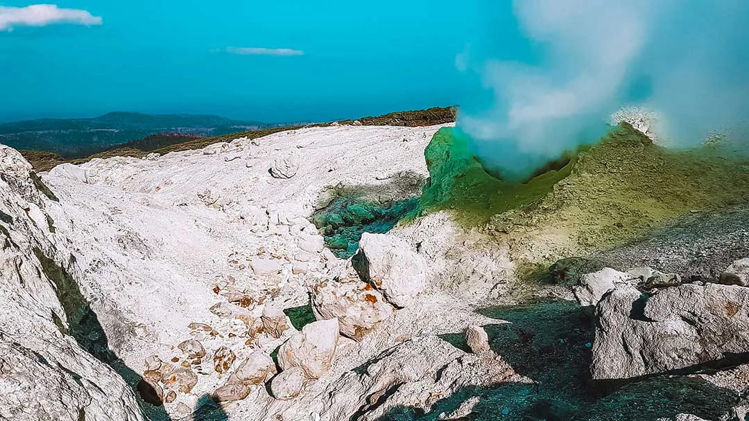
Mendeleev Volcano Fumarole Fields, Kunashir
Four active solfatara fields on the flanks of Mendeleev volcano — sulfur vents at 100–200 °C in silver-fir forest
Description
Four solfatara fields steaming in a silver-fir forest on the flank of an 888-metre Pacific stratovolcano — the Mendeleev fumaroles are the rare place in Russia where you can stand metres from a working sulfur vent without ropes, permits or special gear.
An active volcano on the edge of the Pacific
Mendeleev Volcano (Vulkan Mendeleeva), named in 1946 for the chemist Dmitri Mendeleev, rises 888 metres above the southern end of Kunashir, the closest Kuril Island to Japan. It is a composite stratovolcano made up of a central extrusive dome nested inside the remnants of an older, larger caldera. Steam-and-gas activity was recorded in 1880, 1901, 1946 and 1977; the only confirmed historical eruption is a small phreatic (steam) event in 1880. Since then the volcano has vented continuously through four solfatara fields on the southwest and northern flanks. Smithsonian Global Volcanism Program catalogue number: 290020.
What a fumarole field looks like up close
The fields sit in bare patches of ash and altered rock torn out of the silver-fir forest. Approach is by a narrow trail through head-high Kuril bamboo, and the first sign is olfactory: a sharp sulfur note, then the trees part and open onto a grey-and-yellow moonscape. Vents hiss in clusters, pushing steam and sulfur dioxide between 100 and 200 °C straight out of the ground. Mud pools bubble; older cones are crusted with sulfur crystals the colour of new butter; some rocks are stained rust-red by iron oxidation. The soundscape is continuous — a low hiss everywhere, punctuated by the occasional wet burp from a mud pot.
Each of the four fields has a slightly different character. The southwest field is the largest and most visited, with the widest range of vent temperatures and the fullest range of colour. The northern field is harder to reach but preserves the oldest sulfur trenches — relics of Japanese-era industrial sulfur exploration in the 1920s–30s, when the area was worked at commercial scale.
Science and cultural context
The volcano is monitored year-round by the Institute of Marine Geology and Geophysics in Yuzhno-Sakhalinsk: temperature, gas composition and seismic activity are continuously logged, and the fields serve as a natural laboratory for low-energy volcanic degassing. The site lies inside the Kurilsky State Nature Reserve (established 1984); the fumarole fields themselves are designated a protected natural monument.
On the south-eastern flank, the Mendeleevskaya geothermal power station — a small binary-cycle plant — taps the same heat source to supply Yuzhno-Kurilsk. Where the geothermal water reaches the Pacific, the black volcanic sand of the Hot Beach (Goryachiy Plyazh) is warm underfoot; at low tide you can dig your own pool to soak in.
How guests reach it
From Yuzhno-Kurilsk, a 4×4 covers 17 km of forest track to the trailhead on the volcano's eastern flank. From there, about 3 km on foot through silver fir and Kuril bamboo brings you to the upper field. Round-trip walk is 2–3 hours depending on time on site. With Hot Beach included, the full loop from Yuzhno-Kurilsk takes 7–9 hours.
Practical information
- Season: Mid-June through early October. The trail is most stable July–September; earlier or later, snow may still cover the upper sections.
- Bring: Long sleeves and trousers (Kuril bamboo leaves cut), waterproof boots, gaiters, gloves, a windproof shell — air temperature on the fields runs about 10 °C below the coast. Swimsuit and towel for Hot Beach.
- Safety: Step where the guide steps. Vent geometry shifts with the seasons; do not walk on bright yellow sulfur crusts — the rock beneath can be paper-thin.
- Permits: Kuril border-zone permit (30-day cycle, AMIST handles with the air ticket) and a daily Kurilsky Reserve permit.
How the day unfolds
The Kuril chain has more than thirty active volcanoes; Mendeleev is one of the few that can be safely walked. AMIST has run Kunashir programmes since the early 2010s, when Aurora began regular flights to Mendeleyevo airport. Our southern-Kuril guides are licensed by the Kurilsky Reserve and have walked this trail several hundred times each; groups capped at six, satellite communicator in the lead pack, current knowledge of which vents are stable and what has changed since the last patrol.
Gallery
1 / 1
On the map
Want to see Mendeleev Volcano Fumarole Fields, Kunashir?
We will arrange an excursion to this and other attractions