
Sakhalin
1 photo
Zhdanko Ridge
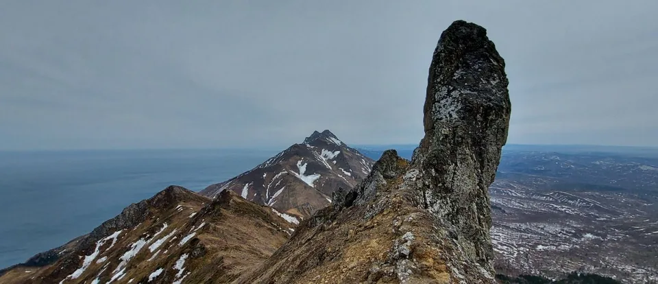
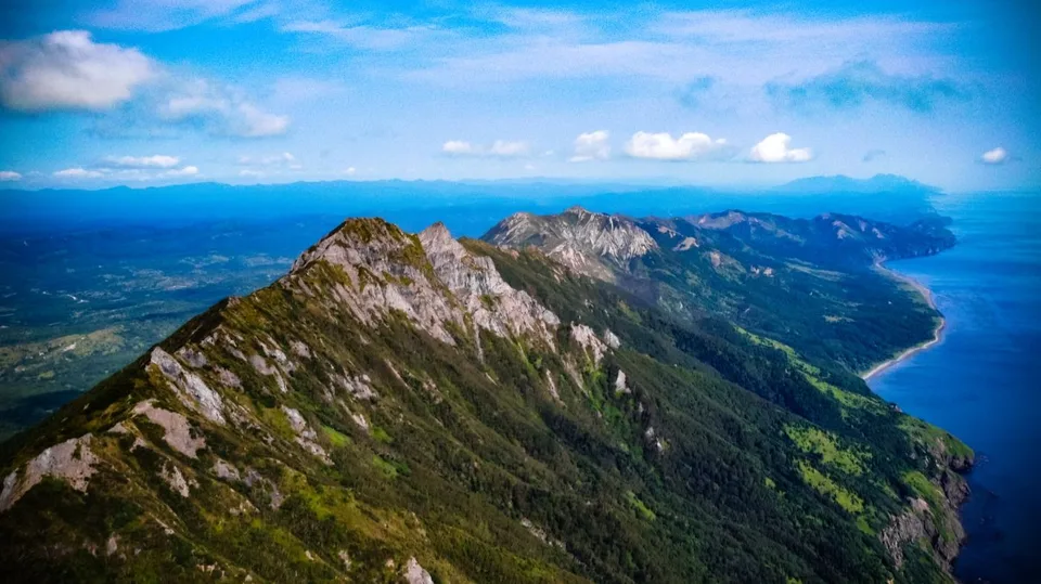
A 13-km razorback of solidified magma above Tikhaya Bay — Mount Zhdanko, 682 m
Description
A 13-kilometre razorback of solidified magma rising straight out of the Sea of Okhotsk, Zhdanko Ridge is the dramatic backdrop to every postcard of Tikhaya Bay — and one of the most photogenic day hikes on Sakhalin.
Geology: an intrusion the mountain never let out
The ridge is the exhumed core of an ancient volcanic intrusion — magma that worked its way up through the eastern Sakhalin sedimentary rocks during the Neogene, cooled before it could break the surface, and has since been stripped of its overburden by 20 million years of erosion. What remains is a long, narrow wall: roughly 13 kilometres end to end, only 1.5 to 2 kilometres wide, culminating in Mount Zhdanko at 682 metres. Both the ridge and the peak were named in 1880 in honour of Mikhail Zhdanko, a Russian naval hydrographer who charted these coasts.
The rock is a tough, dark andesite-basalt that weathers into knife-edged crests and vertical cliffs. Where the ridge meets the sea, the wall drops almost straight into the water; the seaward slopes carry rare botany — edelweiss, Sakhalin peony, and a suite of endemic lichens — that has earned Zhdanko the status of a protected natural monument of Sakhalin Region.
What the visit is like
Two very different experiences share the same mountain. The short version is the photographer's route: a transfer to Tikhaya Bay on the west side of the ridge, a walk along the pebble beach with the razorback filling the sky, and an optional scramble onto the lower shoulders for elevated bay views. The full version is a day hike to the summit of Mount Zhdanko — six to eight hours round trip on a steep, rooty trail that climbs through stone birch and creeping pine before breaking out onto an open crest with the Sea of Okhotsk on one side and Sakhalin's longitudinal spine on the other. From the ridge, passing whales are often visible in August and September.
The ridge is also Sakhalin's climbing mecca: the seaward walls have been used as a training ground since the Soviet period, and a known overhang shelter below the summit serves as an overnight bivouac.
The name and the setting
Zhdanko is part of a separate low-mountain massif that runs roughly 90 km along the island's north–south axis, from Cape Krasny past Cape Nikulin to Cape Mulovsky. The 13-kilometre photogenic block of Zhdanko sits along the eastern shore of the Poyasok isthmus. The high point is Mount Zhdanko itself — Tosso-san (突岨山) in Japanese — at 682 m.
Practical information
- Drive: About three hours from Yuzhno-Sakhalinsk (roughly 130 km via Vzmorye and the Makarov road); pairs well with a Tikhaya Bay day-tour.
- Season: Late June through mid-September. Wind on the crest can be severe; verify the forecast the night before.
- Ascent: 6–8 hours round trip, around 800 m of elevation gain, moderate difficulty; no fixed ropes in summer, but baseline hiking fitness required.
- Bring: Sturdy hiking boots, a genuine windproof shell, two litres of water (no reliable source on the ridge), trekking poles for the descent.
- Photography: The ridge-and-bay frame works best from the south end of Tikhaya in the morning; the summit panorama is best one hour before sunset.
The image guests come for
Without a helicopter or a boat, Zhdanko is the best geological lesson Sakhalin can give a guest. AMIST typically combines the ridge with Tikhaya Bay and Klokovsky Waterfall into a single day, or extends it into a two-day private itinerary with an overnight in Makarov and a summit push the following morning. We hold the group small — on a clear afternoon the upper crest really is yours.
Gallery

1 / 4
On the map
Want to see Гору Жданко?
We will arrange an excursion to this and other attractions