
Sakhalin
1 photo
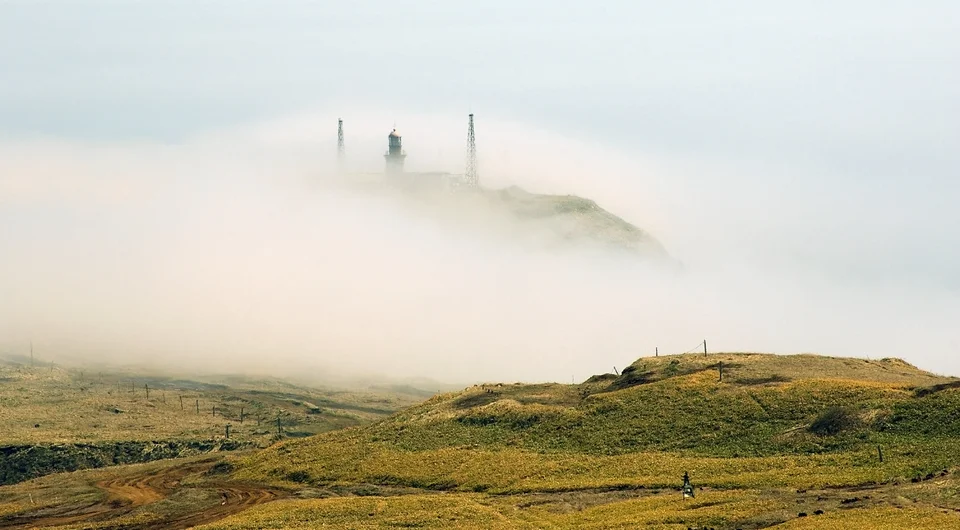
Cape Krilon
Sakhalin's southernmost point — an 1894 Japanese-brick lighthouse and 43 km of strait to Hokkaido
Description
Cape Krilon (Japanese 西能登呂岬, Nishinotoro-misaki) is the southernmost tip of the Krilon Peninsula and of Sakhalin Island as a whole. The cape connects to the peninsula by a narrow, high and abrupt isthmus; the Sea of Japan washes its western side, Aniva Bay of the Sea of Okhotsk the eastern, and the La Perouse Strait — dividing Sakhalin from Hokkaido — sits to the south. On a clear morning, Cape Soya shows as a grey line on the Japanese horizon some 43 kilometres away.
A name, a lighthouse, a border, a century of layers
The cape was named by Jean-François de Lapérouse, the great French navigator, in honour of the French military commander Louis des Balbes de Crillon. The first wooden lighthouse on Krilon was raised in 1883, one of the earliest navigational lights on Sakhalin, answering a stretch of coast notorious for reefs and shipwrecks. In 1894 the structure was rebuilt in Japanese red brick, and during the Karafuto period (1905–1945) the complex was expanded further. After 1945 the cape passed back to the Soviet Union; the Navy added a weather station, additional keepers' housing and signal infrastructure, and Krilon became part of the strategic outer perimeter of the Soviet Far East.
It has kept that status. Today the cape is an active Russian border and military zone: a Pacific Fleet lighthouse, a weather station and a small garrison. An old Russian signal cannon remains on site. The rocky islet known as Kamen Opasnosti — "Dangerous Rock" — sits offshore. Independent travel is not permitted; every civilian visitor must hold an FSB border-zone pass, issued in advance, and travel with an approved operator.
The approach
There is no road to Krilon in any conventional sense. The route runs from Yuzhno-Sakhalinsk south through Nevelsk and Shebunino and then onto a 70-kilometre driveable-beach section — wet sand, wave-pushed gravel, river mouths crossed at low water. Timings are dictated entirely by the tide. Our drivers stage the convoy to hit the fords on falling water and read the swell the way other guides read maps.
On the cape itself you stand on the exact southern tip of Sakhalin, with the Sea of Japan on one side, the Sea of Okhotsk on the other and the open La Perouse Strait ahead. The old brick lighthouse tower, Soviet-era outbuildings and rust-red signal masts sit in a silent compound on the cliff top. Photography is restricted on grounds of military-site protection; our guide briefs the rules in full before you step out of the vehicle.
Practical information
- Permit: An FSB border-zone pass is mandatory. AMIST handles the application end to end; allow 30–60 days, carry your passport throughout.
- Season: Mid-June through mid-September. Outside this window the beach route is impassable.
- Format: Expedition-style 4WD route, typically 2–3 days, with camping or basic base accommodation; everything is tide-driven.
- Bring: Full waterproof outer layer, a warm mid-layer (the strait is cold even in July), sturdy boots, a head-torch, and patience — the weather sets the schedule.
Sakhalin's hardest point
Krilon is the most logistically demanding sight on Sakhalin, and for that reason the most rewarding. The permit paperwork, the tide-driven driving, and the distance from the nearest settlement are precisely what filters out the casual visitor and leaves you alone with a 19th-century lighthouse at the southern tip of a Russian island, looking back across the strait at Japan. AMIST has been running Krilon expeditions for nearly two decades; we manage FSB documentation end to end, run experienced drivers, keep group size small, and turn around without hesitation when weather warns us to.
Gallery
1 / N
On the map
Want to see Cape Krilon?
We will arrange an excursion to this and other attractions