
Island Kunashir
1 photo
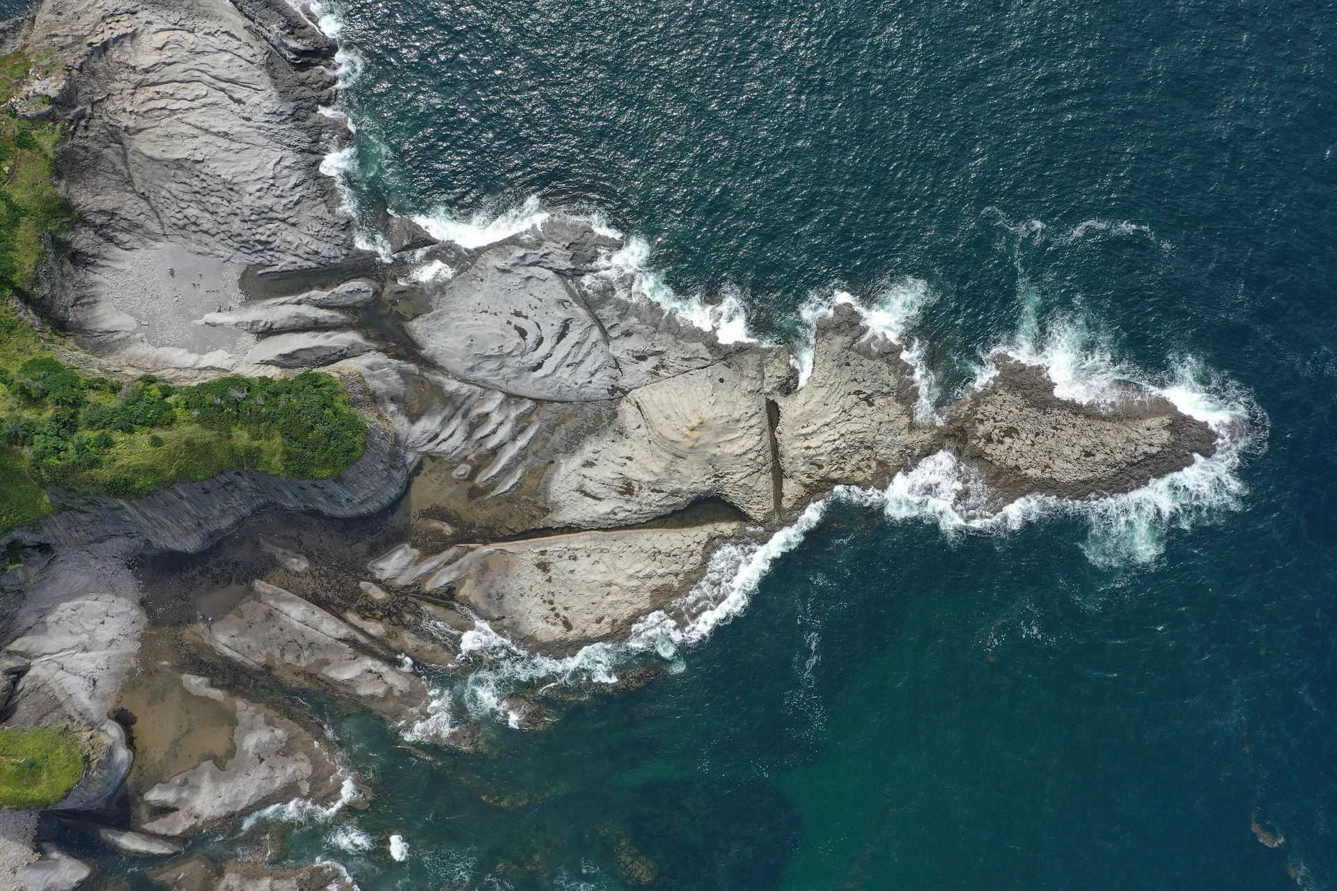
Cape Stolbchaty, Kunashir
A shoreline of thousands of hexagonal basalt columns on south-west Kunashir — a Kuril twin of Giant's Causeway
Description
A Pacific shoreline paved in thousands of perfect hexagons — Cape Stolbchaty is one of the rarest volcanic landforms on earth, and the southern Kurils' most photographed natural monument.
A geological twin of Giant's Causeway
Cape Stolbchaty (Mys Stolbchaty — "Cape of the Columns") sits on the Sea of Okhotsk coast of south-west Kunashir, about 20 km north of Yuzhno-Kurilsk. It is a near-vertical wall of columnar basalt: lava from the ancient Mendeleev Volcano met seawater and cooled under pressure, contracting into pencil-straight prisms with four, five, six or seven sides. The tide has since cut the cliff away, revealing them cleanly — a stone pavement at water level, a stone organ pipe above, and scattered broken columns on the beach that look machined rather than weathered.
Geologically it belongs in a very short global list: Northern Ireland's Giant's Causeway, Iceland's Svartifoss, the Devil's Postpile in California, and Cape Stolbchaty. Of those, Stolbchaty is the only one on an active Pacific Ring of Fire island, and almost certainly the least visited.
What it looks like on the ground
At low tide you walk the hexagonal pavement directly — flat-topped columns polished by the surf, each one a tight geometric fit against the next. Above you the cliff is a honeycomb wall ten to fifteen metres high, streaked with rust-orange lichen and seabird droppings. In places the columns fan out in sprays; in others they lie on their sides, forming a natural stone corduroy. The Pacific breaks directly against the base of the cape, so spray and tide dictate how close you can get. The site is a protected natural monument within the Kurilsky State Nature Reserve (established 1984); a small wooden boardwalk protects the most fragile section, and rangers patrol regularly.
Chekhov described the site in The Island of Sakhalin; Soviet geologists catalogued its columnar jointing systematically in the 1950s; today the cape appears on Kunashir tourist memorabilia and stamps.
Getting there
Access is from Yuzhno-Kurilsk. Two options:
- By sea (preferred): Weather permitting, by Zodiac or small boat along the Pacific coast — about 40 minutes. Only the seaward approach gives you the full wall in scale.
- On foot: Coastal trail from the outskirts of Yuzhno-Kurilsk, 3–4 hours round-trip, passable only at low to mid-tide. The route includes wading several creeks; waterproof boots are essential.
Both options require a Kuril border-zone permit (30-day cycle, AMIST handles with the air ticket) and a daily Kurilsky Reserve permit.
Practical information
- Season: Mid-June through early October. July–August is warmest; September gives the cleanest light and the fewest insects.
- Time on site: 1.5–2 hours, tide-dependent. The pavement is fully walkable only in the low-to-mid-tide window — check the tide table.
- Bring: Waterproof boots or sturdy sandals (for the wading), windproof shell, polariser (it kills the wet-rock glare and lets the hexagonal geometry read in photos). Drone flights require reserve permission; AMIST arranges these in advance for VIP guests.
- Pairings: Mendeleev volcano fumarole fields (same side of the island, 30 minutes by jeep) or Golovnin Caldera (a separate day).
Hexagons without the crowd
Stolbchaty is one of those landscapes people cross the planet to see at Giant's Causeway — and almost no one knows the equivalent stands on Kunashir. AMIST has run southern Kuril programmes since the early 2010s, when Aurora opened regular flights to Mendeleyevo airport. Our Kunashir guides know which specific low tides of the month strip the pavement clean, which weather lets a Zodiac approach safely, and how to position the light so the hexagonal geometry reads in photographs. Small groups only — this cape does not absorb a crowd.
Gallery
1 / N
On the map
Want to see Cape Stolbchaty, Kunashir?
We will arrange an excursion to this and other attractions