Sakhalin
1 photo
Cape Vindis
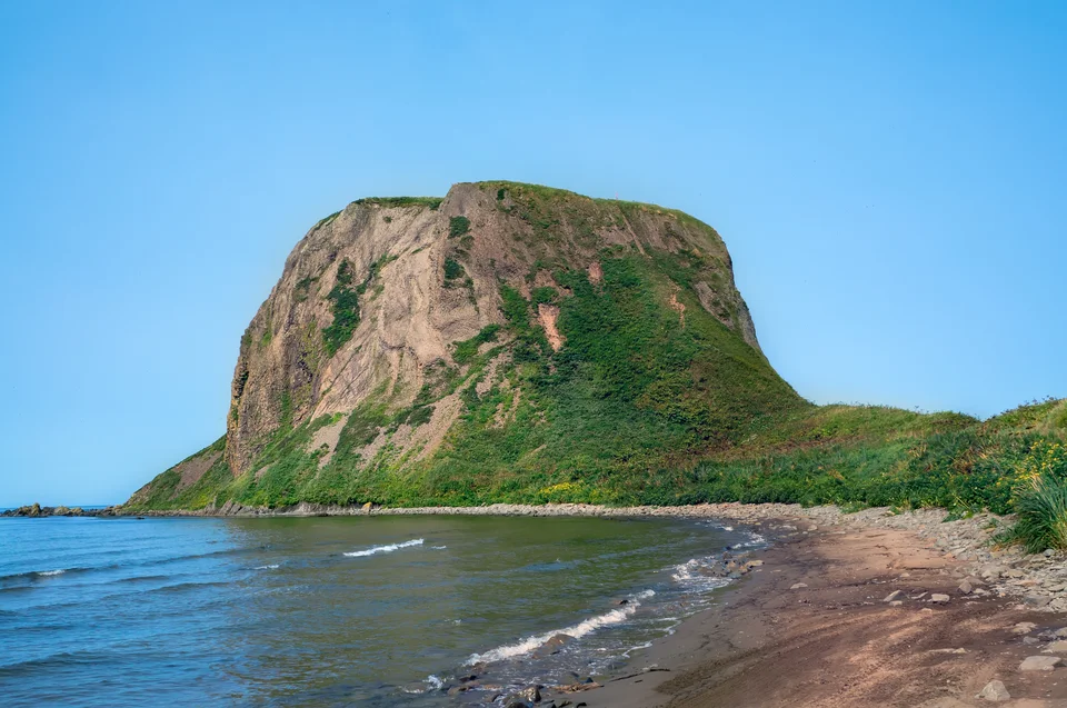
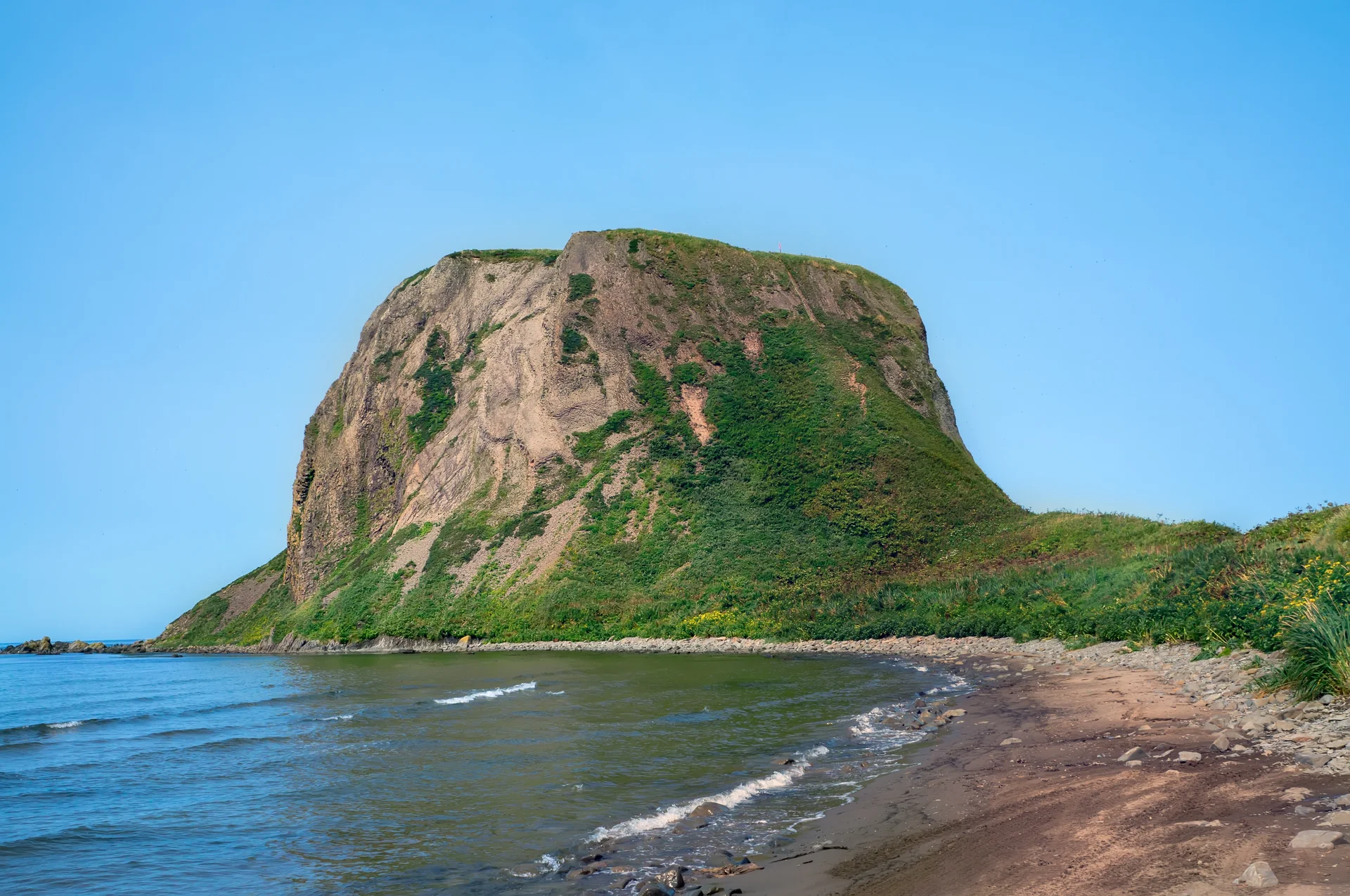
"Kovrizhka" rock 35 km south of Shebunino — a 78-metre basalt column on a sand isthmus
Description
Cape Vindis sits 35 km south of the village of Shebunino on Sakhalin's south-western coast. The headline feature here is a rock that locals call Kovrizhka — "the Loaf" — which, viewed from sea or shore, really does resemble a tall, dense fruit-cake. A dark basalt stack standing as a near-perfect column on a sand isthmus.
Kovrizhka: magma frozen as a column
Kovrizhka rises about 78 metres above sea level and is almost perfectly circular in plan, no more than 100 metres in diameter. A narrow sand isthmus links it to the mainland: at high water it nearly disappears beneath the surf, at low water it emerges as a firm packed strip.
The rock is built of very hard, dark basalt — magma that intruded from below into sedimentary strata, cooled inside them, and froze as a vertical column. Over millions of years wave and wind stripped away the upper and lateral sediments, leaving the hard core in plain view. The geometric near-perfection of the form is a function of that origin, not of weathering.
The shoreline and the setting
The cape sits on the south-western shoulder of the Krilon Peninsula — the long, tapering arm of land that narrows to Cape Krilon at Sakhalin's southern tip. The cape itself is a low rocky shelf of wave-polished boulders and exposed basalt platforms; behind the beach a narrow coastal belt of Kuril bamboo, stone pine and Sakhalin fir presses in. The sea here is rarely calm: cold currents from the La Pérouse Strait keep the water at 4–10 °C even in July, drive fish populations inshore, and make this stretch one of the most productive feeding grounds on the western coast.
The nearest settlement is the village of Shebunino, roughly 12–15 km north along a forest track. There is no infrastructure at the cape itself — no visitor centre, no signed trail — which is precisely what keeps the place in its natural state.
For us, Vindis usually runs in a pair: the "Vindis–Kuznetsova" day is a single jeep loop along the western Krilon. From Vindis on to Kuznetsova is another few hours along the coast; together they give the full picture of Sakhalin's wild western wing — from basalt column to year-round sea lion haul-out.
The approach
From Yuzhno-Sakhalinsk along the south-western highway through Nevelsk and Shebunino, then off onto a forest track and beach section: 3.5–4 hours each way in a 4WD. The final 15 km from Shebunino is unpaved; after heavy rain you need decent ground clearance. The final approach to the foot of Kovrizhka is a short walk across the isthmus.
Practical information
- Permit: The south-west Sakhalin coast is a border-controlled zone; an FSB pass is required. AMIST handles applications — allow 30–60 days, carry passport throughout.
- Season: Mid-June through mid-September. In storms the sand isthmus can be submerged; the guide checks the tide regime before departure.
- Bring: Waterproof boots (the isthmus approach gets wet), a windproof shell, a warm mid-layer (the Sea of Japan stays cool even in July), wide-angle lens for the rock and a polariser.
- Pairings: Vindis usually shares a day with Cape Kuznetsova and Snezhkova Bay — all three sit on the same wing of the Krilon Peninsula.
- Safety: No ascent of Kovrizhka is offered; the photograph is from the beach and the sand isthmus.
Geology, concentrated
Vindis is a short, concentrated geology lesson: one column, one explanation, one frame. For guests who have already seen the southeast coast with Cape Velikan and Cape Ptichy, the western wing with Kovrizhka becomes a natural counterpoint — less postcard, more dry structure. AMIST has worked the Krilon for more than twenty years; we know which tide opens the isthmus both ways and the angle that makes the vertical column read straight.
Gallery
1 / N
On the map
Want to see Cape Vindis?
We will arrange an excursion to this and other attractions