
Island Shikotan
1 photo
An island of the Lesser Kuril Chain — 27 by 13 km, a 412-metre peak, a 1994 earthquake fault and Cape End of the World
An island of the Lesser Kuril Chain — 27 by 13 km, a 412-metre peak, a 1994 earthquake fault and Cape End of the World
Description
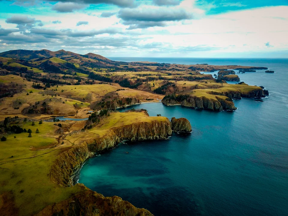
Shikotan is the southernmost permanently inhabited island in the Kuril chain, a piece of solid ground roughly 27 by 13 kilometres set where the Sea of Okhotsk meets the open Pacific. A basalt core under a bamboo blanket, cliffs that drop straight into the water, two fishing villages, and one specific point most travellers come for — Cape End of the World.
Geography and character
The island belongs to the Lesser Kuril Chain (Malaya Kurilskaya Gryada) and to Sakhalin Region of the Russian Federation. The highest point is Mount Shikotan at 412 metres; the interior is a sequence of broad valleys and slopes thickly carpeted with Kuril bamboo (Sasa kurilensis) that limits visibility off the trail to a few metres and gives the island a primordial atmosphere. The eastern shoreline is a near-continuous front of steep volcanic cliffs falling 30 to 50 metres into the Pacific. Large beaches are rare; the dominant coastal material is dark volcanic rock and rounded pebble.
The permanent population is about two thousand, gathered in two settlements. Malokurilskoye on the eastern coast is the administrative centre, with around 1,500 residents and a fisheries economy. The smaller Krabozavodskoye sits on the western side. The two are linked by a few hours on a dirt road through bamboo and low alder.
Mount Shikotan and the 1994 fault
The island's highest peak, 412 metres, stands beside Malokurilskoye. During the Karafuto period the summit held a Japanese sea-observation post; in the Soviet era, military radar stations, now derelict. From the top, much of the island is visible; on a clear day Kunashir and Iturup show on the horizon.
At the foot of the mountain is the island's headline geological feature: a fault that opened here in seconds twenty-eight years ago, during the earthquake of 4 October 1994 (the Shikotan earthquake, M 8.3). A jagged crevice with a narrow entrance cuts the mountain's flank — about 200 metres long, 10–15 metres deep and roughly the same wide. On the floor of the fault stand vertical columns of plate-jointed bedrock, lined up as if measured: an unusual landscape that now draws travellers in its own right.
Cape End of the World and the coast
The most widely known point is Cape End of the World on the northeastern edge: 40-to-50-metre cliffs straight over the open Pacific, with no other land between you and the horizon. Beyond Cape End of the World, Shikotan has Snezhkova Bay in its cliff frame, the unnamed Bay (Bukhta Bezymyannaya), and several lesser-known headlands with seabird colonies.
Getting there
There is no independent travel. Shikotan is a border zone; an FSB permit is mandatory for every visitor. The logistics are combined: flight Yuzhno-Sakhalinsk to Mendeleyevo (Kunashir), then sea transfer to Shikotan; or, when the schedule allows, a chartered direct passage. AMIST consolidates the full chain — permits, tickets, transfer, accommodation in Malokurilskoye.
Practical information
- Season: Late June through mid-September. Kuril fog is routine, and we build flex into every Shikotan itinerary.
- Permit: Mandatory FSB border-zone pass; allow 30–45 working days; carry your passport at all times.
- Time on the island: A minimum of one night, two are better; one-day visits do not work — weather and transfers don't allow it.
- What you see: Cape End of the World; Mt Shikotan with the 1994 fault; coves and headlands; the working life of Malokurilskoye.
- Bring: Waterproof boots (the bamboo trails are wet), full windproof and waterproof shell, warm mid-layer, binoculars for cliff-face seabird colonies.
For the experience, not the box
Shikotan is not a place to tick off. The logic of the island lies in contrast: a long, quiet, hard walk through bamboo, followed by a sudden arrival at a cliff with the Pacific running uninterrupted to the horizon. That sequence is hard to repeat anywhere in Russia or in the world. AMIST has run Kuril programmes since civilian travel opened to the region; local partners in Malokurilskoye hold the transfer and accommodation knots for us. Small groups only — guests come here for the experience, not for the box.
Gallery
1 / 4
On the map
Want to see Гору Shikotan?
We will arrange an excursion to this and other attractions